Zambia Exploration
Large-scale exploration opportunities
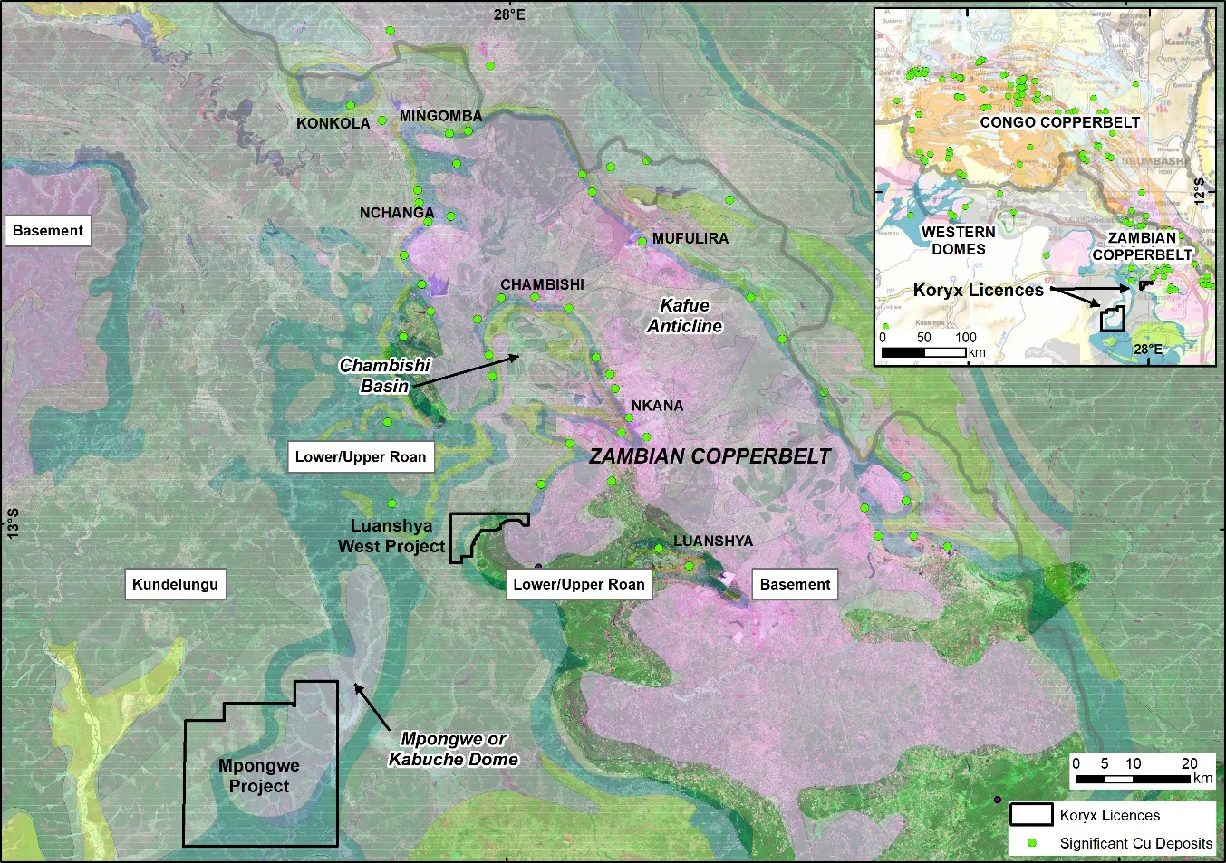
Koryx Copper holds the option to acquire up to 80% of two large-scale exploration licences in the Zambian Copperbelt, which makes up part of the larger Central African Copperbelt (CACB), extending north into the Democratic Republic of Congo. The CACB is the world’s largest sedimentary rock hosted stratiform copper province and includes at least 14 giant deposits.
The licences cover approximately 745 km2
in the heart of the Zambian Copperbelt, close to the western margin of the Kafue Anticline which hosts numerous significant copper deposits, including Nchanga (> 700 Mt @ ~2.5% Cu).
Zambia offers excellent infrastructure and the licences are well located near the regional towns of Kitwe and Mpongwe. Zambia has a long tradition of mining, is a mining-friendly jurisdiction and is very supportive. The President of Zambia recently stated that he will take measures to support the industry to grow the copper production from 800,000 tonnes per year to 3 million tonnes by 2031.
Zambia’s mining and exploration industry is very active with major, mid-tier and junior companies present, including Barrick, First Quantum, Rio Tinto, KoBold, Vedanta and Sino Metals.
Please explore our technical reports providing investors clear insight into the Zambia project.
Key highlights
Prime ground in the heart of the Copperbelt
- Two licences covering ~745 km²
- Located near the western margin of the Kafue Anticline, host to significant copper deposits
- Close to major systems including Nchanga (>700 Mt @ ~2.5% Cu)
Supportive, well-established mining
- Zambia has a long mining tradition and consistently ranks as a mining-friendly jurisdiction
- Strong government backing: the President has targeted an increase in national copper production from 800,000 t/year to 3 million t/year by 2031
- Clear, predictable permitting and strong institutional support
Excellent infrastructure & accessibility
- Licences located near the regional towns of Kitwe and Mpongwe
- Access to roads, power, services, workforce, and major supply routes
- Infrastructure consistent with a region built on 100+ years of continuous mining
Highly active exploration & development region
- Home to major and mid-tiers including Barrick, First Quantum, Rio Tinto, KoBold, Vedanta, and Sino Metals
- One of the most active and competitive exploration belts globally
- A proven setting for discovery and fast-tracked development
Zambia licences
Luanshya West project (LEL 23246)
The large exploration licence is situated centrally on the western margin of the Zambian Copperbelt and covers 5,423.26 hectares (54 km2).
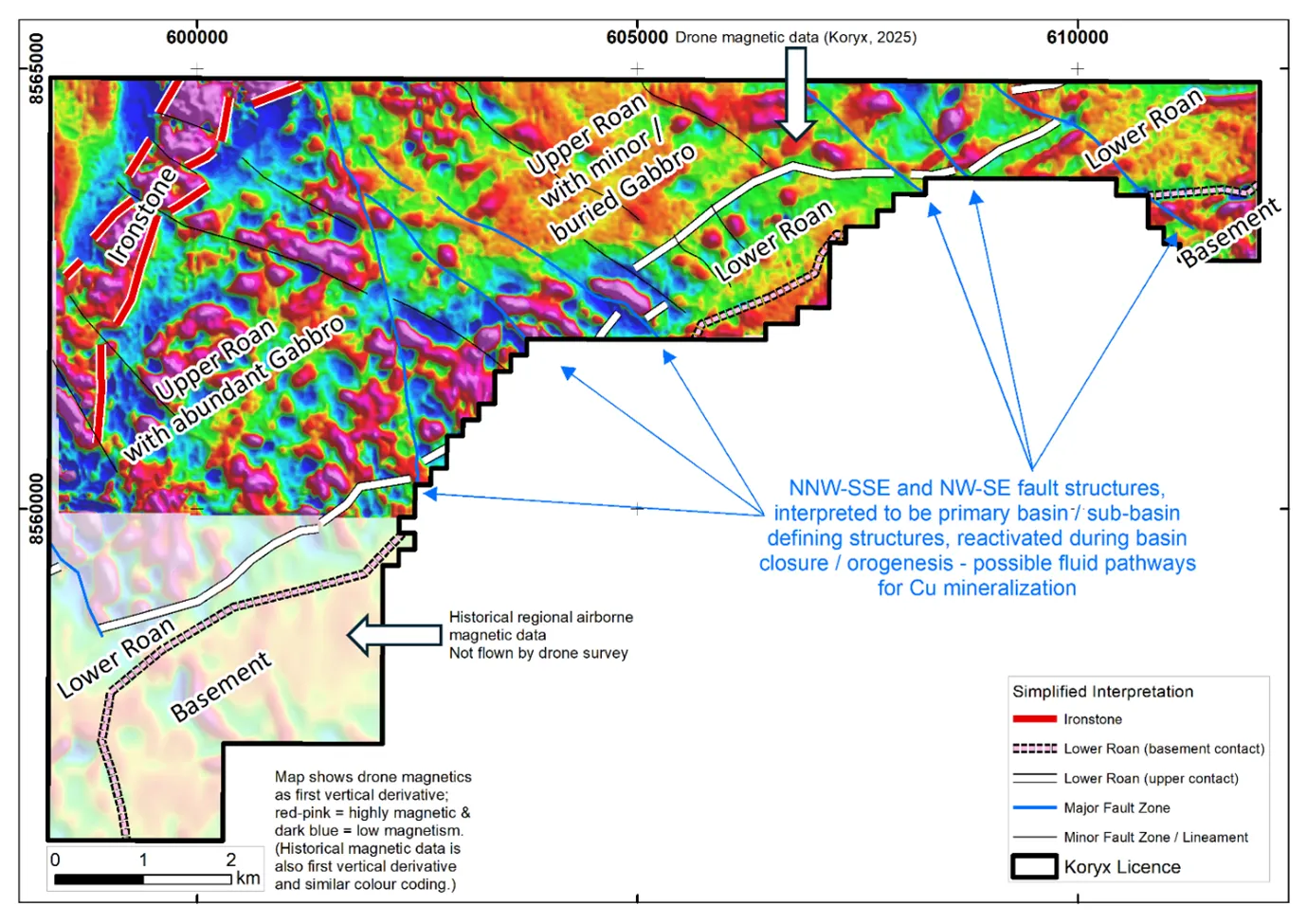
The project is located on the southeastern margin of the area known as the Chambishi or Kakontwe sub-basin where Lower and Upper Roan Subgroup rocks onlap onto the basement dome of the Kafue Anticline. Mineralisation continues to the northeast along the same geological trend, including known deposits at Chibuluma and Chifupu. The Lower Roan rocks host most of the mineralisation in the area around the Chambishi basin and specifically within the footwall arenites. There is also potential for additional mineral discoveries within the licence area, particularly where the Mwashya and Nguba rock formations meet.
The project area is close to established copper mines with Chibuluma mine about 35 km to the north-east, Chambishi mine 40 km north-northeast, Nchanga mine 55 km north-northwest and Luanshya mine some 40 km east-southeast from the centre of the project area.
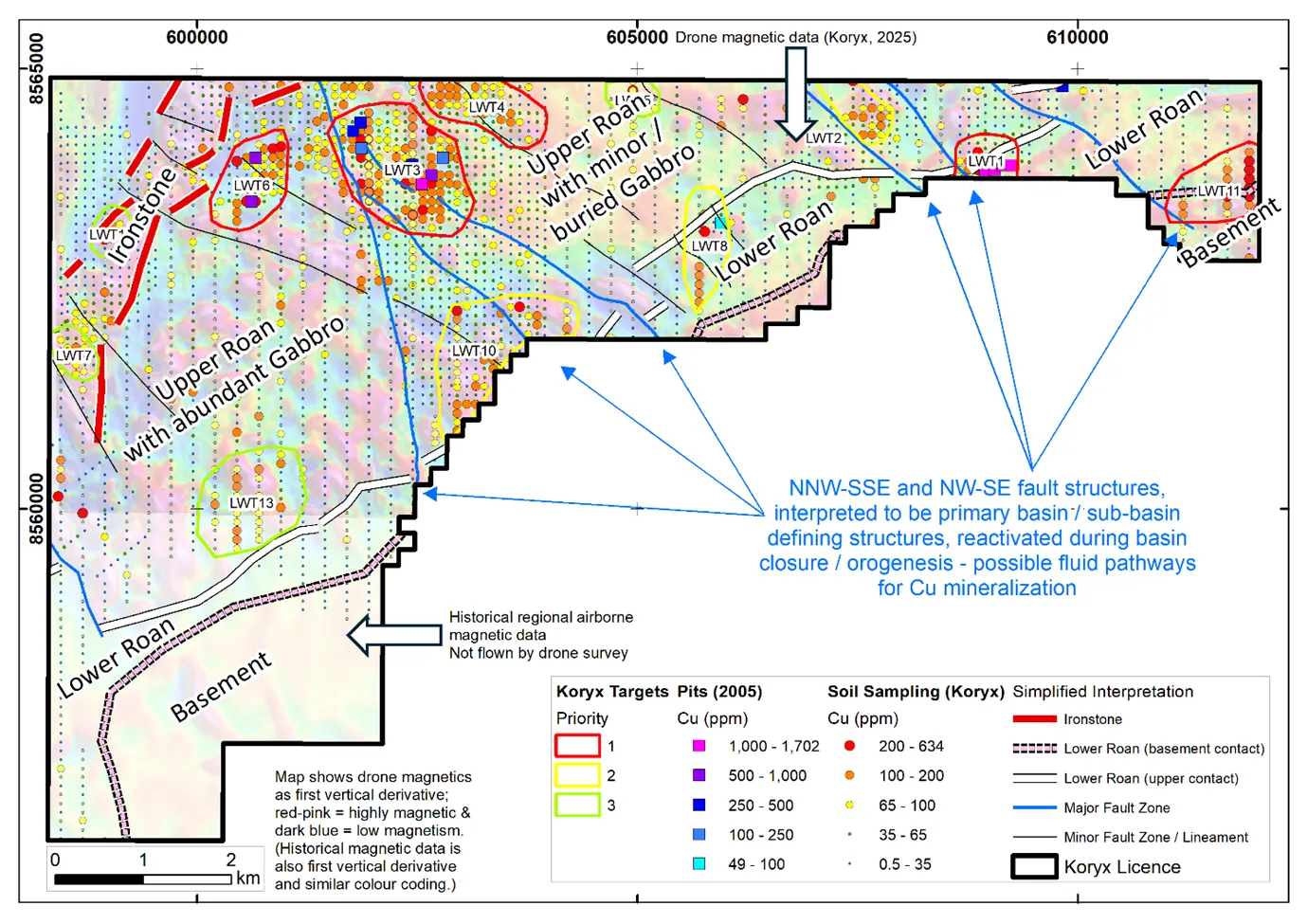
Koryx Copper has completed regional airborne magnetic and satellite imagery data interpretations, geochemical soil sampling and selected induced polarisation (IP) and resistivity surveys. This work has highlighted a number of coincident copper (> 150ppm) +/- cobalt (> 75ppm) in soil and chargeability anomalies in favourable stratigraphic and structural settings. The use of Cu/Sc ratios also allows the discrimination between copper anomalism associated with the meta-sedimentary host rocks and intrusive (Mwashya) gabbroic sills.
The 2025 field programs identified further Cu ± Co soil geochemistry anomalies, better constrained existing anomalies and allowed a more robust ranking of the geochemistry anomalies based on reconnaissance mapping, selected pitting and improved geophysical data coverage and structural interpretation.
A drone-mounted airborne magnetic survey was carried out in mid-2025. The survey was flown at 50m line spacing and aimed to improve on existing historical geophysics data available for the area. The detailed magnetic data has allowed improved lithological and structural interpretations and prioritisation of targets for further work (see maps below).
Follow-up and in-fill soil sampling and analyses of approximately 1,000 samples confirmed existing anomalism, extended previously identified surface geochemical anomalies and added new anomalies and targets.
In addition to the soil sampling, test pits of 1 m to 2.3 m depth were dug on selected targets (LWT1, LWT3 and LWT6) to assess regolith and the nature of the soil anomalism obtained at surface. In general, regolith is composed of iron-rich laterite with variable Mn content, generally >2 m thick, but soils outside of drainages (locally called dambos) are regarded as residual in nature.
At target LWT1, pit samples (in 6 pits) have high Mn values (mean > 4,700 ppm) and coincident elevated Cu (mean > 850 ppm) and Co (mean > 1,100 ppm), suggesting that the elevated Cu-Co might be due to the scavenging effect of the Mn in the lateritic material. Target LWT1 is nevertheless considered a priority target for drill testing, based on IP chargeability anomalism, its location adjacent to a reactivated sub-basin fault, possible facies changes along strike and lack of surface anomalism associated with similar laterites along strike from the anomaly.
Pitting at targets LWT3 and LWT6 indicated moderate increases in Cu values at depths between 1m to 2.3m (up to 1,387 ppm) and low Mn values (<490 ppm). These targets, with their additional characteristics adjacent to faults of interest and IP chargeability anomalies, will be prioritised for drill testing. See below for further discussion of priority targets for drill testing.
A small part of the licence in the southwest was not covered by the drone survey but permission was granted to carry out soil sampling and this was competed at the end of 2025 field season. Results for the additional sampling are currently being interpreted prior to 2026 dry-season field work.
Priority targets which are currently planned for drill testing in 2026 include the following:
LWT1
- Discrete Cu-Co surface geochemistry anomaly (up to 568 ppm Cu and 558 ppm Co), ~400m strike length in upper part of Lower Roan stratigraphy; the target is for mineralisation similar to that found along strike to the northeast, e.g. at Chibuluma South and Chifupu.
- IP (pole-dipole) chargeability anomaly coincident with surface geochemistry.
- Pitting (carried out in 2025) shows elevated Cu (1,618 ppm) and Co (2,231 ppm) between 1.2-1.8 m depth, albeit with high Mn values (>9,000 ppm).
- Adjacent to NW-SE trending fault structure interpreted to control stratigraphy in this area, particularly coarse clastic sedimentary units to the east (indicating facies changes); possible reactivated sedimentary basin structure and hydrothermal fluid pathways.
LWT11
- New, moderate surface geochemistry Cu anomaly identified by 2025 soil sampling (up to 296 ppm Cu); the target is for mineralisation similar to that found along strike to the northeast, e.g. at Chibuluma South and Chifupu.
- Adjacent to NW-SE fault structure, interpreted as a possible hydrothermal fluid pathway.
- Host rocks are basal Lower Roan, with anomaly over 500-1,000 m strike extent.
LWT3
- A broad (1 km x 1.2 km), moderate Cu-Co surface geochemistry anomaly (peak values of 634 ppm Cu and 112 ppm Co), Cu/Sc ratios suggest it is not mafic related anomalism; mineralisation targeted is structurally controlled reduced stratigraphy or orogenic veining analogous to a Kansanshi-style setting.
- IP (pole-dipole) chargeability anomaly at 75-200 m depth coincides with surface geochemistry.
- Pitting (carried out in 2025) shows elevated Cu and Co (1,387 ppm and 277 ppm respectively) between 1-2 m depth, with moderate Mn values (<500 ppm).
- Host rocks are likely to be Upper Roan or possibly Mwashya Subgroup, below the basal Nguba Group ironstones (which occur to the northwest).
LWT4
- Moderate Cu surface geochemistry anomaly (peak values of 602 ppm Cu and 72 ppm Co), Cu/Sc ratios suggest not mafic related anomalism; mineralisation targeted is structurally controlled reduced stratigraphy or orogenic veining.
- IP (pole-dipole) chargeability anomalies with apparent northerly dip, coincide with surface geochemistry.
- Host rocks are likely to be Upper Roan or possibly Mwashya Subgroup and the anomaly could be related to LWT3 (to the southwest) and separated only by small drainages in the area.
LWT6
- Moderate Cu surface geochemistry anomaly (up to 314 ppm Cu, separate peak of 174 ppm Co); mineralisation targeted is structurally controlled reduced stratigraphy or orogenic veining.
- Coincides with NW-SE fault structure, interpreted as a possible hydrothermal fluid pathway.
- Pitting (carried out in 2025) shows moderately elevated Cu (722 ppm) between 1-2 m depth, with moderate Mn values (<400 ppm).
- Host rocks are Upper Roan or possibly Mwashya Subgroup, below basal Nguba Group ironstones.
Planned drilling is likely to include both direct target testing and deeper exploratory drilling aimed at confirming stratigraphic position. Approximately 3,000 m of drilling is planned.
Mpongwe project (LEL 23248)
The large exploration licence is situated to the southwest of the main Zambian Copperbelt and covers 67,500 hectares (675 km2).
The project overlies the southern half of one of the lesser-known basement domes, the Mpongwe or Kabuche Dome, situated to the southwest of the Kafue Anticline and about 80 km southwest of the Luanshya mine. We have taken initial satellite imagery and regional magnetic data interpretations and identified an extensive historical exploration database, which is being compiled and interpreted.
Our preliminary interpretations and reviews of the available historical exploration data suggest that the geology of the area is more complex than the published countrywide geological map suggests. We believe this is an opportunity to apply new models and methods to the exploration of the area, which has only had a limited amount of drilling carried out in the past.
During 2025, we compiled and interpreted historical geophysical and limited geochemical data, and re-logged available historical drill core, including representative magnetic susceptibility measurements and portable XRF analyses. The re-logging of the core suggests the rocks are part of the upper parts of the Roan Group (e.g. Mwashya or Upper Roan Subgroups). This agrees with our interpretation of the historical geophysical data, that the licence area does not contain a significant basement (pre-Katangan) dome (as indicated on the regional published geological maps), unless buried below folded and thrusted Roan Group sedimentary rocks.
Reconnaissance mapping and regional soil sampling commenced in August 2025 and expanded to include first pass regional soil sampling over most of the licence area. A total of approximately 5,000 soil samples was collected, and final results are currently being interpreted.
Interpretation of results will be concluded prior to the end of the wet season with the expectation of commencing a follow-up work program in Q2 2026. If possible, initial drilling will be carried out as part of the planned drill program at Luanshya West.
The technical and scientific information contained on this website has been reviewed and approved by Mr. Dean Richards Pr.Sci.Nat., MGSSA – BSc. (Hons) Geology, who is a ‘Qualified Person’ as defined by National Instrument 43-101 – Standards of Disclosure for Mineral Projects. Please visit www.sedarplus.ca for further information on the technical data provided.